CalTopo is a mapping platform that provides digital tools for planning adventures, missions, and other activities. Gila Backcountry Horsemen utilize CalTopo to document their trailwork in the area.
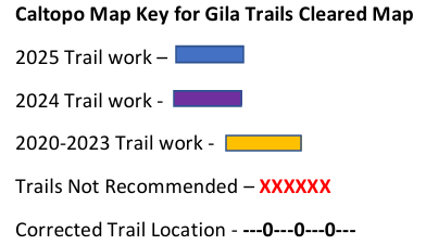
CalTopo Key for Gila Trails Cleared

Caltopo can be challenging to use, but a great resource.
The easily updated Caltopo map has some inherent challenges. There are pros and cons to all mapping programs. Once a user gets used to this mapping system, planning trips with relative ease. Meanwhile, the info below may be helpful when using.
Where is the Map Key
Sometimes the detailed map key is hidden. To view it, simply click on the arrow on the left-hand side in the middle of the page. That will cause the map key to be visible.
What does “Trail Recommended” Mean?
These trails are either impassable or obliterated. To see a list of why each trail is impassable, go to the Trails Not Recommended chart – Gila and Aldo Leopold Wilderness only
What does “GPS Trail Correction” Mean?
This shows where the trail actually is in comparison to where other maps say the trail is. Sometimes these differences can be significant.
I don’t know the trails by number - only by name. What should I do?
Click on the trail, to see the name of the trail. Another option is the Trails Cleared Document for the Gila Wilderness. It has the name of the trail next to the correlated number.
The trail list does not help me because I don’t know where each trail is?
Click on a specific trail listed on the left side bar. The Caltopo map will automatically zoom in to that trail location. We apologize that Caltopo will not let us list the trails in a certain order. You will need to scroll down the list.
What type of trail work was done on the highlighted trails?
Click on a trail to see what trail work was completed. Sometimes a trail is improved one way but not completely. Trail work may include brushing, removing small to medium logs, cross cutting or removing large logs, tread work, drainage work, and trail marking.
How can I download the data in KML, GPX or geoJSON?
On the top left of the Caltopo map page, click on export and choose which file type you want. It will than let you choose which data you would like to export. You can then upload this information into your own mapping systems such as gps.
Can I create my own map with the trails information on it?
To create a map with the Caltopo basemap and the trail information, click on Print (which is on the top left of the Caltopo map page). Choose Printed Maps. A new page will open that will allow you to choose the size, shape and area the map covers. Then click Generate PDF. It will open the new PDF/JPEG in a new window. You can then save the map to your device.
Elevation gains and loss information for each trail
Click on the trail you are wanting information about. A box will open next to the trail. Click on “Profile” or “Terrain Statistics”.

